Yes! Send me the FREE digital editions of Spa Business and Spa Business insider magazines and the FREE weekly Spa Business and Spa Business insider ezines and breaking news alerts!
At Space Syntax, research and analysis are helping define how
urban professionals have a role to play in achieving healthy outcomes for all. Eime Tobari and Eleri Jones discuss some of the findings
Urban design can take the lead to create places that benefit citizens’ health Credit: shutterstock
Until recently, the relevance of health to the realm of urban planning and design was not widely accepted or acknowledged. Now, however, there is a common understanding globally that health is a complex issue that relates to all aspects of our everyday lives and is influenced by the built environment, as well as by sociocultural and economic factors.
In our increasingly complex and interrelated urban environments, this means that positive health outcomes must be considered holistically and cannot be focused on particular segments of the population. This statement was recognised by the 9th Global Conference on Health Promotion, which was held in Shanghai, China, in the November of 2016, when the goal of “health for all, all for health” was agreed upon and was furthermore referenced by Chinese president Xi Jinping in his opening speech at the event.
Politicians, at both the city and national levels, will play a critical role in ensuring that positive health outcomes for all are prioritised. However, professionals in urban planning and design around the world are well positioned to take a lead role on this agenda by creating places that support better health outcomes and the wellbeing of citizens in urban areas, many of which are growing at a rapid pace.
Design options and health outcomes A number of guidelines and tools have been developed by multilaterals, governmental and voluntary sector organisations to ensure that positive health outcomes are included in decision-making processes at every governance level. At the international level, the World Health Organisation (WHO) published a Health Economic Assessment Tool (HEAT) that estimates the economic impact of walking and cycling. They also promote the Health Impact Assessment (HIA), which is a framework to assess the health impact of policies, urban planning and development projects. Sustrans, in partnership with TAS Partnership and Living Streets, developed an Active Travel Toolbox, which links health outcomes with investment, housing growth and air quality. Transport for London published Healthy Streets for London, which includes guidelines in promoting active travel (walking, cycling and public transport).
While all of these toolkits and guidelines are very helpful in terms of highlighting the importance of good health outcomes, in practice, the principles which underpin these guidelines are often not applied to urban planning and design decisions. This is in part because there is a lack of quantifiable measures which urban professionals can use to objectively test the impact that design options might have on health outcomes.
Using urban layouts Space Syntax is an approach to understanding how the spatial structure of places impacts movement and behaviour. Recent advances in our analytical capability have enabled us to start to investigate how health outcomes are impacted by the spatial structure of urban areas. This research has led us to develop tools which allow for a quantitative assessment of different policy interventions, such as increasing public transport provision in underserved areas.
It is generally accepted that increased public transport provision improves access to services and employment. This in turn can have a positive impact on health, both physical and mental, as it reduces social isolation and encourages people to undertake active travel. While these associations are well known, it is not easy to identify where exactly the improved public transportation should be routed to ensure it improves the lives of the people that need it the most.
Street network analysis Through Space Syntax analysis, we can provide insights with this level of granularity, enabling evidence-based decisions on a range of possible policy interventions. For example, analysis of the maps on the opposite page can demonstrate why there is a high level of car dependency in Milton Keynes: the street network, when combined with public transport availability and where jobs are located, means that private vehicles become a natural choice for a large portion of the population. The maps can also then show policymakers precisely which parts of the city would benefit most from greater public transport availability.
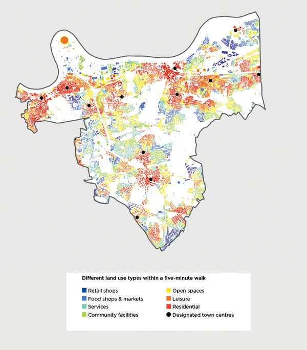
On the other hand, the London Borough of Greenwich, shown in the image on the right, has a spatial structure which is far more ‘compact’. Our analysis of the street network in the image below shows how many different land uses are available within a five-minute walking distance from many residential buildings. The warmer the colour is, the more types of land uses residents can reach within five minutes, on foot.
What this analysis means in practice is that policy makers can see that many residents in this area are able to access effective town, local and neighbourhood centres. This means cars are less likely to be a necessity for day-to-day activities (apart from perhaps a commute to work, which is not included in this analysis) and therefore air pollution is likely to be lower. Residents are also likely to be getting regular exercise as they go about their daily lives. However, even in this compact urban layout, there are still areas that are relatively segregated. Using this tool, planners can see precisely where these areas are and what additional public transport would be most effective to improve access to local services for people living there.
Creating healthier places The outputs of these tools, and the conclusions derived from them, may appear to be a statement of the obvious, which are underpinned by relatively simple analyses. However, two overarching lessons for those involved in planning and designing cities can be drawn from them. Firstly, our analysis demonstrates how significant a factor spatial structure is in encouraging active travel. Streets form the foundation of our urban fabric and are not as easy to change as public realm or individual buildings. It is therefore crucial that this foundation is designed to encourage behaviours that contribute to better health and supports creation of healthier places.
By this, we mean a built environment that supports and promotes the physical and mental health of the people who use it. This requires the right balance of interconnectedness, movement, awareness, encounter and exchange at every scale. It means the delivery of places in which different kinds of human activity can thrive - as demonstrated in the case study on the opposite page, which is a proposal for improving the layout of Union Square in Washington, DC. Space Syntax proposed improving exiting routes and crossing points, which increased walkability around the square as well as creating resting spots to watch other people from – one of the main activities in public places.
Secondly, while the links between urban form and health outcomes are accepted and well known, the application of systematic, quantitatively driven analysis to inform specific planning decisions is not commonplace. Instead, generalised principles are applied in a broad-brush manner to all urban environments, without considering the unique spatial characteristics that impact how they function and how they influence behaviours.
A targeted application of the very sound principles set out in documents such as the HIA is required to deliver the known health benefits of, for example, active travel. This requires complex models that combine a range of datasets spatially, such as the ones shown above. At Space Syntax, these models are called Integrated Urban Models and they link urban planning and design parameters, such as street layout, land use, plot sizes and development quantum, with health-related outcomes such as walkability and car dependency – and allow us to see interactions between them. An example of this can be seen on the following page, which shows the proposed master plan of Darwin city centre in Australia and the creation of a new, local, walkable centre in an Extension Area.
A data-driven and spatial approach Health is important to all of us and, of course, to our future generations. So why has the topic not been a top priority in urban planning and design discussions? It is not necessarily because urban planners or designers do not recognise its importance – it is because integrating health outcomes into the decision-making process is very challenging.
We have seen how using data and sophisticated modelling techniques, such as those detailed above, can help to make this task easier. However, this cannot be undertaken by planners alone. There is still a need for open, collaborative discussion across professions, disciplines and sectors, underpinned by robust evidence and principles, if design is to realise positive health outcomes for all citizens. Health should be a central topic throughout the process of planning and design from strategic spatial strategy, transport strategy and land use allocations through to public realm and building design.
For this process to be efficient and effective, a collaboration between planning, transport and public health teams in particular is essential. There are already some exciting, formalised collaborations in existence. For example, Transport for London has a public health expert who is pushing a healthy places agenda. In the UK, the Local Government and Public Involvement in Health Act 2007 requires Primary Care Trusts to work with Local Authorities to develop a Joint Strategic Needs Assessment (JSNA), which links various functions of Local Authorities with health issues and promotes collaborations between a range of departments.
Time to act Such collaborations can also be supported and facilitated by sharing datasets and models. This can help align work in different teams by creating a common ground, which also makes cross-team communications easier. In this way, data and modelling can provide a common language between various experts and facilitate collaborations between them.
But we also need to go beyond talking and start acting if we are to avoid the very real challenges that poor health-related outcomes pose for the future generations who inhabit our cities. We know, through careful analysis of evidence and case studies, that positive health outcomes can be delivered through a variety of design decisions that typically require insights and inputs from many different disciplines and professions.
We now need to apply focused, localised data analytics to identify exactly where that expertise and insight can be applied to best effect, creating a planning and design process which can respond to the specific needs of the people that live in our cities.
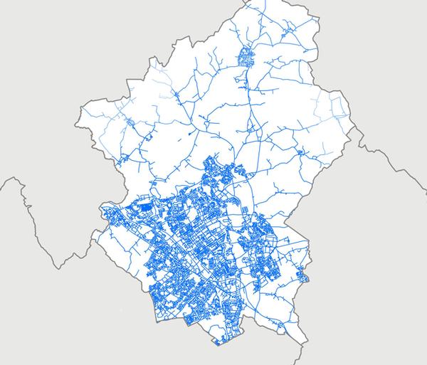
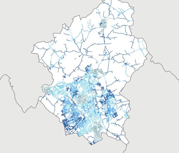
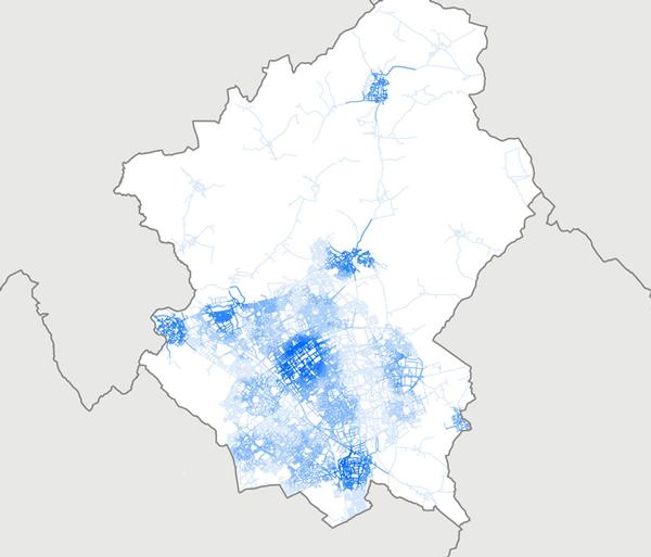
Urban planning Milton Keynes The images show the number of job opportunities (commercial uses) in Milton Keynes reachable in 15-minute journeys in each transport mode. The darker it is, more job opportunities available within 15-minute journeys. Car dependency was calculated as a ratio between the number of job opportunities available within the same journey time between public transport and private vehicles. The darker is it, the greater the advantage of private vehicles is. The closer to pale grey, the closer the advantage of both transport modes are. However, in this case, the public transport option does not outweigh private vehicles.
Private car
Private car vs Public Transport
Public Transport
Walking
London Borough of Greenwich Different land use types within a five-minute walk
Union Square, Washington, DC Union Square is located at the eastern end of the National Mall and in front of the State Capitol Building. The design proposal extends the exiting east-west routes of the National Mall straight into the heart of the space. Combined with improved crossing points, this will enhance the connection between the National Mall and the space.
In Union Square, a series of convenient diagonal routes connect visitors with strategic points in the pedestrian movement network, such as the roundabouts at the ends of Pennsylvania, Maryland and Louisiana Avenues.
A new north-south link is introduced along the alignment of Second Street connecting the site better locally and with the US Botanical Gardens. Within this network, new spaces to rest and enjoy the Square and its significant views are created around the basins and at the basin of the Grant Memorial. These locations will be excellent spots for watching people, a main activity in public space. Such stationary activity will contribute to the attraction of this space, which will increase significantly as a result of the redesign. The combined impact of the proposed spatial interventions would have a significant impact on pedestrian activity potentials within the space as well as on the eastern part of the National Mall.
Darwin, Australia In 2012, the City of Darwin secured a grant from the Commonwealth Government of Australia to produce a master plan for the city centre of Darwin. The purpose of this plan is to provide a road map for development of the city for the next 20 years. To accommodate growth, the city centre needs to be extended and reinforced. Space Syntax was asked to join a design team led by Design Urban. Our role was to provide comprehensive urban analysis and strategic design input to support the creation of the master plan. A key aim of the project was to facilitate private sector investment and population growth through the production of high quality public realm.
Space Syntax’s work has underpinned the creation of the Darwin City Centre Master Plan. Quantified indications of its social and economic impacts have facilitated meaningful discussions between different disciplines, bringing architects, transport engineers, planners and politicians together with a wide stakeholder base.
About the authors
Eime Jones and Eime Tobari
Eleri Jones, associate at Space Syntax, leads the Urban Policy and Foresight team, which supports the strategic development and growth of the company through research and stakeholder engagement activities. Prior to this, Jones led the Foresight Future of Cities project in the UK Government Office for Science and held a variety of posts in the Cabinet Office and DCLG.
Dr Eime Tobari, associate director at Space Syntax, has extensive research experience in architecture and sociology, focusing on the relationship between space and its behavioural, social and economic outcomes. She has been involved with projects ranging from the internal layout of buildings to city-wide masterplanning. Tobari has been focusing on promoting a health and wellbeing agenda in urban planning and design.
Many different types of place can be accessed
by foot in Greenwich Credit: shutterstock
Crossing points and
rest stops can boost an area’s attractiveness Credit: shutterstock
Public health should
be a central topic in the planning of urban spaces Credit: shutterstock
With an increasing number of luxury hotels and resorts offering day and resort passes to
drive staycation business, Book4Time, a leader in innovative spa and wellness solutions, is
thrilled to announce the launch of Day & Resort Passes on its award-winning platform. [more...]
At Space Syntax, research and analysis are helping define how
urban professionals have a role to play in achieving healthy outcomes for all. Eime Tobari and Eleri Jones discuss some of the findings
Urban design can take the lead to create places that benefit citizens’ health Credit: shutterstock
Until recently, the relevance of health to the realm of urban planning and design was not widely accepted or acknowledged. Now, however, there is a common understanding globally that health is a complex issue that relates to all aspects of our everyday lives and is influenced by the built environment, as well as by sociocultural and economic factors.
In our increasingly complex and interrelated urban environments, this means that positive health outcomes must be considered holistically and cannot be focused on particular segments of the population. This statement was recognised by the 9th Global Conference on Health Promotion, which was held in Shanghai, China, in the November of 2016, when the goal of “health for all, all for health” was agreed upon and was furthermore referenced by Chinese president Xi Jinping in his opening speech at the event.
Politicians, at both the city and national levels, will play a critical role in ensuring that positive health outcomes for all are prioritised. However, professionals in urban planning and design around the world are well positioned to take a lead role on this agenda by creating places that support better health outcomes and the wellbeing of citizens in urban areas, many of which are growing at a rapid pace.
Design options and health outcomes A number of guidelines and tools have been developed by multilaterals, governmental and voluntary sector organisations to ensure that positive health outcomes are included in decision-making processes at every governance level. At the international level, the World Health Organisation (WHO) published a Health Economic Assessment Tool (HEAT) that estimates the economic impact of walking and cycling. They also promote the Health Impact Assessment (HIA), which is a framework to assess the health impact of policies, urban planning and development projects. Sustrans, in partnership with TAS Partnership and Living Streets, developed an Active Travel Toolbox, which links health outcomes with investment, housing growth and air quality. Transport for London published Healthy Streets for London, which includes guidelines in promoting active travel (walking, cycling and public transport).
While all of these toolkits and guidelines are very helpful in terms of highlighting the importance of good health outcomes, in practice, the principles which underpin these guidelines are often not applied to urban planning and design decisions. This is in part because there is a lack of quantifiable measures which urban professionals can use to objectively test the impact that design options might have on health outcomes.
Using urban layouts Space Syntax is an approach to understanding how the spatial structure of places impacts movement and behaviour. Recent advances in our analytical capability have enabled us to start to investigate how health outcomes are impacted by the spatial structure of urban areas. This research has led us to develop tools which allow for a quantitative assessment of different policy interventions, such as increasing public transport provision in underserved areas.
It is generally accepted that increased public transport provision improves access to services and employment. This in turn can have a positive impact on health, both physical and mental, as it reduces social isolation and encourages people to undertake active travel. While these associations are well known, it is not easy to identify where exactly the improved public transportation should be routed to ensure it improves the lives of the people that need it the most.
Street network analysis Through Space Syntax analysis, we can provide insights with this level of granularity, enabling evidence-based decisions on a range of possible policy interventions. For example, analysis of the maps on the opposite page can demonstrate why there is a high level of car dependency in Milton Keynes: the street network, when combined with public transport availability and where jobs are located, means that private vehicles become a natural choice for a large portion of the population. The maps can also then show policymakers precisely which parts of the city would benefit most from greater public transport availability.
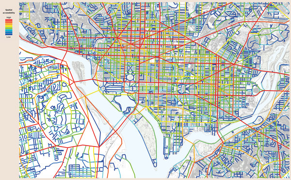
On the other hand, the London Borough of Greenwich, shown in the image on the right, has a spatial structure which is far more ‘compact’. Our analysis of the street network in the image below shows how many different land uses are available within a five-minute walking distance from many residential buildings. The warmer the colour is, the more types of land uses residents can reach within five minutes, on foot.
What this analysis means in practice is that policy makers can see that many residents in this area are able to access effective town, local and neighbourhood centres. This means cars are less likely to be a necessity for day-to-day activities (apart from perhaps a commute to work, which is not included in this analysis) and therefore air pollution is likely to be lower. Residents are also likely to be getting regular exercise as they go about their daily lives. However, even in this compact urban layout, there are still areas that are relatively segregated. Using this tool, planners can see precisely where these areas are and what additional public transport would be most effective to improve access to local services for people living there.
Creating healthier places The outputs of these tools, and the conclusions derived from them, may appear to be a statement of the obvious, which are underpinned by relatively simple analyses. However, two overarching lessons for those involved in planning and designing cities can be drawn from them. Firstly, our analysis demonstrates how significant a factor spatial structure is in encouraging active travel. Streets form the foundation of our urban fabric and are not as easy to change as public realm or individual buildings. It is therefore crucial that this foundation is designed to encourage behaviours that contribute to better health and supports creation of healthier places.
By this, we mean a built environment that supports and promotes the physical and mental health of the people who use it. This requires the right balance of interconnectedness, movement, awareness, encounter and exchange at every scale. It means the delivery of places in which different kinds of human activity can thrive - as demonstrated in the case study on the opposite page, which is a proposal for improving the layout of Union Square in Washington, DC. Space Syntax proposed improving exiting routes and crossing points, which increased walkability around the square as well as creating resting spots to watch other people from – one of the main activities in public places.
Secondly, while the links between urban form and health outcomes are accepted and well known, the application of systematic, quantitatively driven analysis to inform specific planning decisions is not commonplace. Instead, generalised principles are applied in a broad-brush manner to all urban environments, without considering the unique spatial characteristics that impact how they function and how they influence behaviours.
A targeted application of the very sound principles set out in documents such as the HIA is required to deliver the known health benefits of, for example, active travel. This requires complex models that combine a range of datasets spatially, such as the ones shown above. At Space Syntax, these models are called Integrated Urban Models and they link urban planning and design parameters, such as street layout, land use, plot sizes and development quantum, with health-related outcomes such as walkability and car dependency – and allow us to see interactions between them. An example of this can be seen on the following page, which shows the proposed master plan of Darwin city centre in Australia and the creation of a new, local, walkable centre in an Extension Area.
A data-driven and spatial approach Health is important to all of us and, of course, to our future generations. So why has the topic not been a top priority in urban planning and design discussions? It is not necessarily because urban planners or designers do not recognise its importance – it is because integrating health outcomes into the decision-making process is very challenging.
We have seen how using data and sophisticated modelling techniques, such as those detailed above, can help to make this task easier. However, this cannot be undertaken by planners alone. There is still a need for open, collaborative discussion across professions, disciplines and sectors, underpinned by robust evidence and principles, if design is to realise positive health outcomes for all citizens. Health should be a central topic throughout the process of planning and design from strategic spatial strategy, transport strategy and land use allocations through to public realm and building design.
For this process to be efficient and effective, a collaboration between planning, transport and public health teams in particular is essential. There are already some exciting, formalised collaborations in existence. For example, Transport for London has a public health expert who is pushing a healthy places agenda. In the UK, the Local Government and Public Involvement in Health Act 2007 requires Primary Care Trusts to work with Local Authorities to develop a Joint Strategic Needs Assessment (JSNA), which links various functions of Local Authorities with health issues and promotes collaborations between a range of departments.
Time to act Such collaborations can also be supported and facilitated by sharing datasets and models. This can help align work in different teams by creating a common ground, which also makes cross-team communications easier. In this way, data and modelling can provide a common language between various experts and facilitate collaborations between them.
But we also need to go beyond talking and start acting if we are to avoid the very real challenges that poor health-related outcomes pose for the future generations who inhabit our cities. We know, through careful analysis of evidence and case studies, that positive health outcomes can be delivered through a variety of design decisions that typically require insights and inputs from many different disciplines and professions.
We now need to apply focused, localised data analytics to identify exactly where that expertise and insight can be applied to best effect, creating a planning and design process which can respond to the specific needs of the people that live in our cities.
Urban planning Milton Keynes The images show the number of job opportunities (commercial uses) in Milton Keynes reachable in 15-minute journeys in each transport mode. The darker it is, more job opportunities available within 15-minute journeys. Car dependency was calculated as a ratio between the number of job opportunities available within the same journey time between public transport and private vehicles. The darker is it, the greater the advantage of private vehicles is. The closer to pale grey, the closer the advantage of both transport modes are. However, in this case, the public transport option does not outweigh private vehicles.
Private car
Private car vs Public Transport
Public Transport
Walking
London Borough of Greenwich Different land use types within a five-minute walk
Union Square, Washington, DC Union Square is located at the eastern end of the National Mall and in front of the State Capitol Building. The design proposal extends the exiting east-west routes of the National Mall straight into the heart of the space. Combined with improved crossing points, this will enhance the connection between the National Mall and the space.
In Union Square, a series of convenient diagonal routes connect visitors with strategic points in the pedestrian movement network, such as the roundabouts at the ends of Pennsylvania, Maryland and Louisiana Avenues.
A new north-south link is introduced along the alignment of Second Street connecting the site better locally and with the US Botanical Gardens. Within this network, new spaces to rest and enjoy the Square and its significant views are created around the basins and at the basin of the Grant Memorial. These locations will be excellent spots for watching people, a main activity in public space. Such stationary activity will contribute to the attraction of this space, which will increase significantly as a result of the redesign. The combined impact of the proposed spatial interventions would have a significant impact on pedestrian activity potentials within the space as well as on the eastern part of the National Mall.
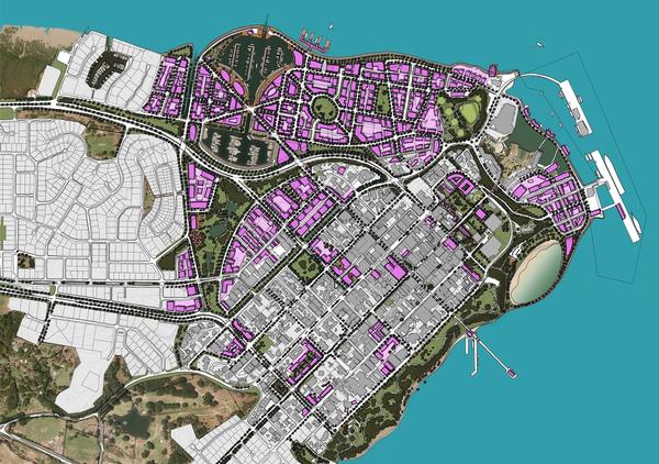
Darwin, Australia In 2012, the City of Darwin secured a grant from the Commonwealth Government of Australia to produce a master plan for the city centre of Darwin. The purpose of this plan is to provide a road map for development of the city for the next 20 years. To accommodate growth, the city centre needs to be extended and reinforced. Space Syntax was asked to join a design team led by Design Urban. Our role was to provide comprehensive urban analysis and strategic design input to support the creation of the master plan. A key aim of the project was to facilitate private sector investment and population growth through the production of high quality public realm.
Space Syntax’s work has underpinned the creation of the Darwin City Centre Master Plan. Quantified indications of its social and economic impacts have facilitated meaningful discussions between different disciplines, bringing architects, transport engineers, planners and politicians together with a wide stakeholder base.
About the authors
Eime Jones and Eime Tobari
Eleri Jones, associate at Space Syntax, leads the Urban Policy and Foresight team, which supports the strategic development and growth of the company through research and stakeholder engagement activities. Prior to this, Jones led the Foresight Future of Cities project in the UK Government Office for Science and held a variety of posts in the Cabinet Office and DCLG.
Dr Eime Tobari, associate director at Space Syntax, has extensive research experience in architecture and sociology, focusing on the relationship between space and its behavioural, social and economic outcomes. She has been involved with projects ranging from the internal layout of buildings to city-wide masterplanning. Tobari has been focusing on promoting a health and wellbeing agenda in urban planning and design.
Many different types of place can be accessed
by foot in Greenwich Credit: shutterstock
Crossing points and
rest stops can boost an area’s attractiveness Credit: shutterstock
Public health should
be a central topic in the planning of urban spaces Credit: shutterstock
The historic Breakers Hotel in Long Beach, California, is set to reopen in mid-2024 as a
Fairmont Hotels & Resorts property after a significant restoration and redevelopment project.
Marriott International has signed a new deal with Neom to open a Ritz-Carlton Reserve property
as part of Trojena, a brand new year-round mountain adventure destination in Saudi Arabia.
The Bannatyne Group says it has officially bounced back from the pandemic, with both turnover
and profits restored to pre-2020 levels in 2023, according to its year-end results.
While British adults are the most active they’ve been in a decade, health
inequalities remain with the same groups missing out, according to Sport
England’s latest Active Lives Adults Report.
Kerzner International has signed deals to operate two new Siro recovery hotels in Mexico and
Saudi Arabia, following the launch of the inaugural Siro property in Dubai this February.
Nuffield Health’s fourth annual survey, the Healthier Nation Index, has found people moved
slightly more in 2023 than 2022, but almost 75 per cent are still not meeting WHO guidelines.
The US spa industry is continuing its upward trajectory, achieving an unprecedented milestone
with a record-breaking revenue of US$21.3 billion in 2023, surpassing the previous high of
US$20.1 billion in 2022.
Short-term incentives for exercise, such as using daily reminders, rewards or games, can lead
to sustained increases in activity according to new research.
With an increasing number of luxury hotels and resorts offering day and resort passes to
drive staycation business, Book4Time, a leader in innovative spa and wellness solutions, is
thrilled to announce the launch of Day & Resort Passes on its award-winning platform. [more...]